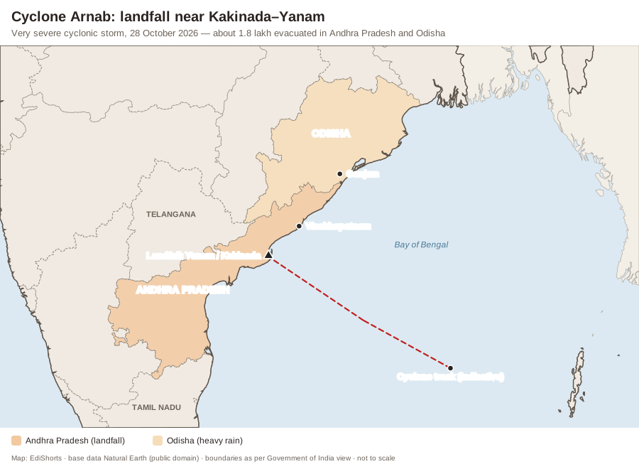
Why in News: Cyclone Arnab, a Very Severe Cyclonic Storm, made landfall on the Andhra Pradesh coast near Yanam (Puducherry) and Kakinada early on 28 October 2026, with sustained winds of about 115–135 km/h. The landfall process lasted over six hours. More than 1.8 lakh people were evacuated in Andhra Pradesh and Odisha; at least three deaths were reported, three airports suspended operations and heavy rain lashed southern Odisha before the storm weakened into a deep depression. The name, meaning “ocean” in Bengali, was reportedly contributed by Bangladesh.
Why October–November Cyclones Are Dangerous
- The post-monsoon season (October–December) is the second cyclone season of the North Indian Ocean; Bay of Bengal storms in this period are often the most intense.
- Warm sea-surface temperatures (above 26.5°C) to depth, high humidity, low vertical wind shear and remnants of Pacific typhoons crossing South-East Asia feed Bay storms.
- The Bay’s funnel shape and shallow continental shelf along Andhra and Odisha pile up storm surges; the 1977 Diviseema and 1996 Konaseema cyclones devastated this same Godavari delta coast.
India’s Cyclone Preparedness
- Accurate IMD track forecasts, early warnings via SMS (Common Alerting Protocol) and mass evacuation have cut deaths sharply — Odisha’s “zero casualty” approach after the 1999 Super Cyclone is a global model.
- National Cyclone Risk Mitigation Project (World Bank-assisted): multipurpose cyclone shelters, evacuation roads, underground cabling.
- Remaining gaps: damage to crops, power and fishing boats; slow restoration; coastal erosion and mangrove loss.
Static Background — Tropical Cyclones
- Formation: warm ocean (≥ 26.5°C), Coriolis force (cyclones do not form within about 5° of the Equator), pre-existing low pressure, low wind shear, upper-level divergence.
- Rotation: anticlockwise in the Northern Hemisphere, clockwise in the Southern.
- Structure: calm eye surrounded by the eyewall (strongest winds and rain) and spiral rain bands.
- Names: assigned from a list prepared by the WMO/ESCAP Panel on Tropical Cyclones (13 member countries contributed 169 names in 2020); the Regional Specialised Meteorological Centre at IMD, New Delhi, names cyclones in the North Indian Ocean.
- Bay of Bengal sees about four times as many cyclones as the Arabian Sea, though the Arabian Sea has been warming faster.
| IMD category | Maximum sustained wind (km/h) |
|---|---|
| Depression | 31–49 |
| Deep Depression | 50–61 |
| Cyclonic Storm | 62–88 |
| Severe Cyclonic Storm | 89–117 |
| Very Severe Cyclonic Storm | 118–166 |
| Extremely Severe Cyclonic Storm | 167–221 |
| Super Cyclonic Storm | 222 and above |
Exam Angle — Prelims & Mains
- UPSC PYQ Link: Mains GS-1 has asked why the Bay of Bengal sees more cyclones than the Arabian Sea and about cyclone naming; Prelims about conditions for cyclone formation.
- Practice Mains Question (GS Paper 3, 10 marks, 150 words): India has sharply reduced cyclone deaths but not cyclone losses. Discuss the next steps for coastal resilience in the light of Cyclone Arnab.
- Prelims Angle: categories, naming body and formation conditions.
- Practice Prelims MCQ 1: Consider the following statements:1. Tropical cyclones rotate anticlockwise in the Northern Hemisphere.2. Tropical cyclones commonly form right along the Equator because sea temperatures are highest there.3. The Regional Specialised Meteorological Centre in New Delhi names cyclones over the North Indian Ocean.Which of the statements given above are correct?(A) 1 and 2 only(B) 2 and 3 only(C) 1 and 3 only(D) 1, 2 and 3
Show answer
Answer: (C) 1 and 3 only — Statement 1 is CORRECT and Statement 3 is CORRECT. Statement 2 is INCORRECT — the Coriolis force is negligible near the Equator, so cyclones rarely form within about 5° of it. - Practice Prelims MCQ 2: A cyclone with maximum sustained winds of 130 km/h would be classified by IMD as a:(A) Severe Cyclonic Storm(B) Super Cyclonic Storm(C) Extremely Severe Cyclonic Storm(D) Very Severe Cyclonic Storm
Show answer
Answer: (D) — Winds of 118–166 km/h define a Very Severe Cyclonic Storm.
- Practice Prelims MCQ 1: Consider the following statements: