Why in News: In early October 2026 heavy rain in Nepal and high discharge released from the Valmikinagar barrage on the Gandak breached embankments and ring bunds in Bihar, flooding villages in the West Champaran–Gopalganj belt. The episode, coming late in a dry monsoon year, showed how localised extreme rain in the Himalayan catchment can flood the plains even when national rainfall is below normal.
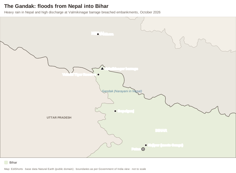
The Gandak River
- Rises in the Nepal Himalaya (the Kali Gandaki, which cuts one of the world’s deepest gorges between Dhaulagiri and Annapurna, joins with other streams to form the Narayani or Sapta Gandaki).
- Enters India at Valmikinagar (Triveni) and flows through Uttar Pradesh and Bihar to join the Ganga at Hajipur, opposite Patna — the Sonepur cattle fair is held near the confluence.
- Gandak Agreement between India and Nepal (1959, revised 1964): India built the barrage at Valmikinagar (Bhainsalotan) for irrigation and power, with benefits to Nepal.
Why North Bihar Floods Every Year
- Rivers from Nepal (Ghaghara, Gandak, Bagmati, Kamla, Kosi, Mahananda) carry huge sediment; they change course and overtop or breach embankments.
- About three-quarters of north Bihar is flood-prone; Bihar is India’s most flood-prone State.
- Embankments give a false sense of safety and trap water behind them (drainage congestion); breaches — like the Kosi breach at Kusaha in 2008 — are catastrophic.
Way Forward
- Real-time flood forecasting with Nepal (data sharing from upstream gauges); joint planning of storage dams such as the long-discussed Kosi high dam and Pancheshwar.
- Maintenance and audit of embankments; “room for the river” approaches and flood-plain zoning.
- Community preparedness: raised platforms, boats, flood shelters and crop insurance.
Static Background — Ganga Tributaries and India–Nepal Water Treaties
- Left-bank (Himalayan) tributaries of the Ganga: Ramganga, Gomti, Ghaghara, Gandak, Burhi Gandak, Bagmati, Kosi, Mahananda.
- Right-bank: Yamuna, Son (from Amarkantak), Tons, Punpun.
- Kosi — the “Sorrow of Bihar”; Damodar was the “Sorrow of Bengal” (tamed by the Damodar Valley Corporation, 1948).
- India–Nepal river agreements: Kosi (1954), Gandak (1959), Mahakali Treaty (1996, Pancheshwar project).
- Flood management: Flood Management and Border Areas Programme (FMBAP); the Rashtriya Barh Ayog (1976) estimated 40 million hectares of India as flood-prone.
| Treaty | Year | River |
|---|---|---|
| Kosi Agreement | 1954 | Kosi |
| Gandak Agreement | 1959 | Gandak |
| Mahakali Treaty | 1996 | Mahakali (Sharda) |
Exam Angle — Prelims & Mains
- UPSC PYQ Link: Prelims has asked about the Ganga’s tributaries and their order from west to east; Mains GS-1 on floods in the Ganga plains.
- Practice Mains Question (GS Paper 1, 10 marks, 150 words): Why do the rivers of north Bihar flood almost every year? Discuss structural and non-structural measures to reduce the damage.
- Prelims Angle: confluences, tributaries and treaties.
- Practice Prelims MCQ 1: Arrange the following left-bank tributaries of the Ganga from west to east:1. Gandak2. Ghaghara3. Kosi4. GomtiSelect the correct answer using the code given below:(A) 4-2-1-3(B) 2-4-1-3(C) 4-1-2-3(D) 2-1-4-3
Show answer
Answer: (A) 4-2-1-3 — The Gomti joins near Ghazipur, the Ghaghara near Chhapra, the Gandak at Hajipur and the Kosi near Kursela in the east. - Practice Prelims MCQ 2: The Gandak joins the Ganga at:(A) Allahabad (Prayagraj)(B) Varanasi(C) Bhagalpur(D) Hajipur, opposite Patna
Show answer
Answer: (D) — The confluence is near Hajipur–Sonepur, opposite Patna.
- Practice Prelims MCQ 1: Arrange the following left-bank tributaries of the Ganga from west to east: