Why in News: Three incidents in October 2026 highlighted the vulnerability of sea lanes. Two Singapore-registered container ships, GFS Pride and GFS Giselle, were hit by unidentified projectiles while transiting the Strait of Hormuz (15 October); a Turkish-owned cargo ship carrying Ukrainian corn sank after Russian drone strikes outside Romanian waters in the Black Sea (early October); and satellite images showed an oil spill from a suspected damaged tanker, Gem No. 2, spreading towards the UAE’s northern coast (late October).
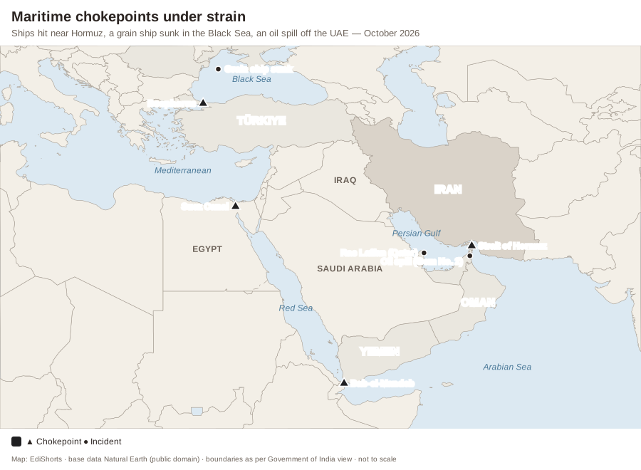
Why Chokepoints Matter
- Strait of Hormuz: connects the Persian Gulf to the Gulf of Oman; about a fifth of global oil consumption and a large share of LNG pass through it. A large share of India’s crude and LNG imports also comes through Hormuz.
- Bab-el-Mandeb: links the Red Sea and the Gulf of Aden; attacks by Yemen’s Houthis since 2023 diverted shipping around the Cape of Good Hope, adding 10–14 days to Europe–Asia voyages.
- Suez Canal: about 12% of world trade; Bosphorus and Dardanelles (Turkish Straits) control the Black Sea, through which Ukraine and Russia ship grain.
Impact on India
- Higher freight and war-risk insurance costs; delayed exports (hence the RELIEF scheme’s insurance cover); price spikes in crude and LNG.
- Indian seafarers are among the largest groups of crew on merchant ships — their safety is a direct concern.
- Indian Navy deployments: Operation Sankalp (since 2019) escorts Indian-flagged ships in the Gulf of Oman; ships deployed in the Arabian Sea and Gulf of Aden against piracy and drone threats.
Oil Spills — Environmental Damage
- Spills smother coral, mangroves and seagrass, kill seabirds and fish, and damage desalination plants that Gulf countries depend on for drinking water.
- Responses: booms, skimmers, dispersants and bioremediation; India has a National Oil Spill Disaster Contingency Plan led by the Coast Guard.
Static Background — Straits and Sea Lanes
- Strait of Hormuz — between Iran and Oman (Musandam); Bab-el-Mandeb — between Yemen and Djibouti/Eritrea; Strait of Malacca — between Malaysia/Singapore and Sumatra (Indonesia); Palk Strait — between India and Sri Lanka; Bosphorus — through Istanbul; Strait of Gibraltar — Spain and Morocco.
- UNCLOS (1982): transit passage through international straits; territorial sea of 12 nautical miles, EEZ of 200 nautical miles.
- Montreux Convention (1936) governs the Turkish Straits.
- The “Malacca dilemma” — China’s dependence on that strait for energy imports.
| Strait | Connects | Bordering countries |
|---|---|---|
| Hormuz | Persian Gulf – Gulf of Oman | Iran, Oman |
| Bab-el-Mandeb | Red Sea – Gulf of Aden | Yemen, Djibouti, Eritrea |
| Malacca | Andaman Sea – South China Sea | Malaysia, Singapore, Indonesia |
| Bosphorus | Black Sea – Sea of Marmara | Türkiye |
Exam Angle — Prelims & Mains
- UPSC PYQ Link: Prelims frequently asks which countries border a strait (e.g., Bab-el-Mandeb, Hormuz, Malacca); Mains GS-3 on energy security and maritime security.
- Practice Mains Question (GS Paper 2, 15 marks, 250 words): Chokepoints have become flashpoints. Discuss the implications of insecurity at Hormuz and Bab-el-Mandeb for India and the measures India has taken.
- Prelims Angle: strait–country pairs and UNCLOS zones.
- Practice Prelims MCQ 1: Consider the following pairs:1. Bab-el-Mandeb — Red Sea and Gulf of Aden2. Strait of Hormuz — Persian Gulf and Gulf of Oman3. Bosphorus — Black Sea and Caspian SeaHow many of the pairs given above are correctly matched?(A) Only one(B) Only two(C) All three(D) None
Show answer
Answer: (B) Only two — Pair 1 is correct and pair 2 is correct. Pair 3 is incorrect — the Bosphorus links the Black Sea to the Sea of Marmara; the Caspian Sea is landlocked. - Practice Prelims MCQ 2: Under UNCLOS, the Exclusive Economic Zone extends up to how many nautical miles from the baseline?(A) 12(B) 24(C) 200(D) 350
Show answer
Answer: (C) — The EEZ extends to 200 nautical miles; the territorial sea is 12 and the contiguous zone 24 nautical miles.
- Practice Prelims MCQ 1: Consider the following pairs: