Why in News: Protests against the proposed 11,200 MW Siang Upper Multipurpose Project (SUMP) in Arunachal Pradesh turned violent on the night of 23 October 2026 in Pasighat, East Siang district — an NHPC office and a police station were set on fire, police vehicles damaged and the houses of political leaders vandalised. The violence followed a bandh across Siang, Upper Siang and East Siang districts. Prohibitory orders under Section 163 of the BNSS were imposed; Chief Minister Pema Khandu condemned the violence and offered dialogue, noting that only pre-feasibility work is under way.
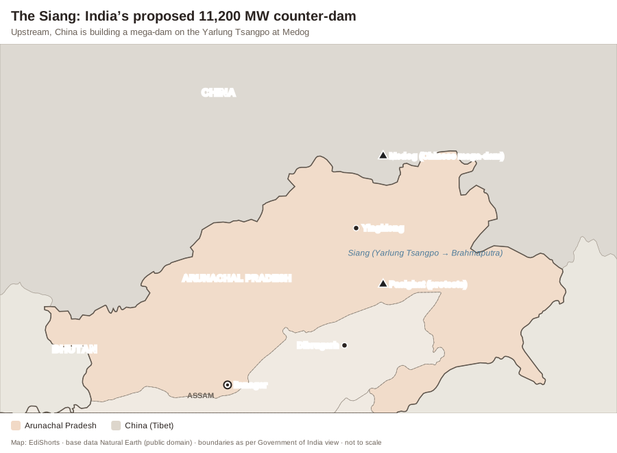
The Strategic Logic
- China began building a giant hydropower project on the lower Yarlung Tsangpo at Medog in July 2025 — reportedly about 60 GW, the world’s largest.
- India fears sudden water releases (“water bombs”), reduced lean-season flows and loss of sediment downstream; the SUMP’s large reservoir is meant to act as a buffer and assert India’s prior use of the water.
- It would also be among India’s largest hydropower and storage projects.
Why Local Communities Oppose It
- Displacement and submergence of villages, farmland and forests of the Adi community; fear of loss of land under customary ownership.
- Cultural attachment to the Siang (“Ane Siang” — Mother Siang).
- Safety: the region lies in seismic zone V; the 1950 Assam–Tibet earthquake changed river courses.
- Distrust over surveys conducted with heavy security deployment and limited consultation.
Balancing Interests
- Free, prior and informed consultation with communities; transparent cost-benefit and downstream studies.
- Fair compensation, benefit-sharing (free power, local jobs) and rehabilitation.
- Smaller run-of-river options and data-sharing diplomacy with China as complements.
Static Background — The Brahmaputra System
- Source: Chemayungdung glacier near Mansarovar, Tibet; flows east as the Yarlung Tsangpo, takes a U-turn around Namcha Barwa (the Great Bend) and enters India as the Siang (Dihang) at Gelling.
- Near Sadiya in Assam, the Siang joins the Dibang and the Lohit to form the Brahmaputra; it enters Bangladesh as the Jamuna and joins the Padma (Ganga).
- Major tributaries: Subansiri (largest), Manas, Teesta, Kameng (right bank); Burhi Dihing, Dhansiri, Kopili (left bank).
- India–China cooperation: an Expert Level Mechanism (2006) on trans-border rivers; MoUs for China to share flood-season hydrological data on the Brahmaputra and Sutlej — no water-sharing treaty.
- Arunachal Pradesh: about 50 GW of identified hydropower potential, the highest of any State.
| River stretch | Name |
|---|---|
| Tibet | Yarlung Tsangpo |
| Arunachal Pradesh | Siang / Dihang |
| Assam | Brahmaputra |
| Bangladesh | Jamuna |
Exam Angle — Prelims & Mains
- UPSC PYQ Link: Prelims has asked about the Brahmaputra’s tributaries and course (e.g., 2017 on the Teesta); Mains GS-3 on large dams and displacement.
- Practice Mains Question (GS Paper 3, 15 marks, 250 words): Strategic infrastructure in ecologically sensitive border regions must win local consent. Examine with reference to the Siang Upper Multipurpose Project.
- Prelims Angle: course of the Brahmaputra and its names.
- Practice Prelims MCQ 1: Consider the following statements:1. The Siang, Dibang and Lohit join near Sadiya to form the Brahmaputra.2. The Subansiri is a left-bank tributary of the Brahmaputra.3. India and China have a treaty for sharing the waters of the Brahmaputra.Which of the statements given above is/are correct?(A) 1 only(B) 1 and 2 only(C) 2 and 3 only(D) 1, 2 and 3
Show answer
Answer: (A) 1 only — Statement 1 is CORRECT. Statement 2 is INCORRECT — the Subansiri is a right-bank tributary. Statement 3 is INCORRECT — there are only data-sharing MoUs. - Practice Prelims MCQ 2: The Yarlung Tsangpo enters India in which State?(A) Sikkim(B) Assam(C) Arunachal Pradesh(D) Nagaland
Show answer
Answer: (C) — It enters Arunachal Pradesh at Gelling in Upper Siang district as the Siang.
- Practice Prelims MCQ 1: Consider the following statements: